CPS Resource Centre
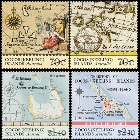
Australia Cocos (Keeling) Islands, 2014-06-24
On June 24, 2014 Austraila Post issued a set of four map stamps depicting the Cocos (Keeling) islands from different periods during the islands’ history. The first European sighting of the Cocos (Keeling) Islands is thought to have been in 1609, by Englishman Captain William Keeling of the East India Company. Soon after, the two atolls that comprise the islands started to appear on maps. The stamps are composed of various maps from a particular century that show the atolls which comprise the Cocos (Keeling) islands. The 70c denomination is a joined pair, featuring maps of the 17th and 18th centuries. From the Australia Post web site, “a number of different maps and navigational charts have been used in the design of the four stamps, including: L’Arcano del Mare (Secrets of the Sea) (1646); Hemisphere oriental ou Ancien Monde (c. 1783); and Karte von dem Morgenlandischen Ocean oder dem Indischen Meere (1758). The single $1.40 denomination features a oceanagraphic chart from the 19th century. The single $2.10 denomination features a topographic map from the 20th century, with what appears to depict a large scale view of “Home Island,” one of the two inhabited islands in the group.