CPS Resource Centre
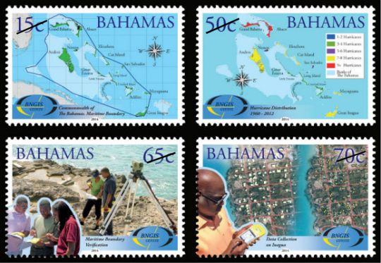
On July 21, 2014, the Bahamas Postal Service released a new set of stamps commemorating the 10th anniversary of the establishment of the Bahamas National Geographic Information Systems (BNGIS) Center. The Center was founded on July 26, 2004. The set of four stamps feature denominations of 15c, 50c, 65c and 70c. The stamps feature various paper and digital maps and photographs of technicians surveying in the field. The mission of the BNGIS is to promote, educate, coordinate and advance both the practical and efficient use of GIS in the Bahamas. The 15c stamp shows the delineation of the maritime boundaries of the islands, which was finalized in 2008, which are a critical part of territorial sovereignty. The Bahamas archipelago is comprised of 700 atolls, cays and rocks with a total land area of 15107 sq.km which extends over 259,000 sq. km. of shallow banks and ocean area. A thematic map of Hurricane Distribution from 1960 – 2012 is depicted on the 50c stamp. The 65c stamp shows technicians from the BNGIS, working with the members of the Royal Bahamas Defence Force conducting a field verification to check the accuracy of specific the base points used to create the maritime baseline. What appears to be a digital level or total-station is shown in the foreground of the stamp. The 70c stamp depicts a technician, in the foreground, with a GPS field recorder and an aerial photo, in the background, of a neighborhood with road center lines, on Inagua island where field data collection and verification were carried out. The colorful set of stamps also features the BNGIS logo on each stamp. This is the second issue of 2014 which features new data collection technologies and screen images of GIS/computer mapping software. [ please let us know of any other recent GIS related stamp issues – admin ]
Bahamas, 2014-07-21