United Kingdom 2009-01-13 A single First Class rate stamp featuring the Harry Beck designed “London Underground Map” was featured as part of the British Design Classics, issued by Royal Mail on January 13, 2009. The first “Tube” map was designed in 1931 by Beck, an Underground employee, with the concept being based on an electrical diagram. Beck continued to create maps for the London Underground until 1960. [ subway maps for other cities are often draw using a similar style. does anyone know of any other subway map stamps? –web admin]
On November 10, 2008 Indonesia Post issued a set of stamps depicting various small and outer islands “Pulau-pulau Kecil Terluar / The Small Outermost Islands” in the Indonesian chain of islands. The stamps feature a photograph of the island, and a locator map. A full sheet of stamps,
 Indonesia 2008-11-10 shown above, contains 16 stamps in four sets for four different designs. In the center of the full sheet is a large detailed map of Indonesia with the names of many of the outter islands, and red lines indicating which islands are shown in the stamps. A smaller size sheet containg only the 16 stamps without the large center map was also issued. The detailed map in the center of the full sheet will be of keen interest to fellow CartoPhilatelists.
 Latvia 2008-11-07 On November 7, 2008 Latvian Post issued a single stamp that commemorates the 90th anniversary of the founding of the Republic of Latvia on November 18, 1918. The stamp shows the Latvian Coat of Arms overlaid on the national flag in the shape of the country boundary. This issue of 500,000 stamps is printed in sheets of ten by Cartor Security Printing.


Here is an interesting souvenir sheet, shown below, issued by Belarus on December 16, 2007. The single stamp souvenir sheet commemorates the Struve Geodetic Arc, a project lasting from 1816-1855 by German-born Russian scientist Friedrich Georg Wilhelm von Struve to determine the exact size and shape of the Earth. The original arc consisted of 258 triangulations with 265 station points. The arc passed through 10 countries and extended over 2800km, stretching from Norway to the Black Sea. Today, 34 of the original station points have been designated as a World Heritage Site. In 1964 Russia issued a stamp, shown on the right, marking the centenary of Struve’s death in 1894. [ while researching this sheet, a lot of interesting history and web sites are available. one such site is dedicated to World Cultural Heritage as shown on stamps. ]
 Spain 2006-07-13 On July 13th, 2006, Spain’s Postal Service, Correos, issued two stamps which appear to be the start of a series dealing with Earth and space sciences. A very representative cartophilatelic issue showing a detailed 1:200,000 scale topographic of Toledo and the surrounding region is shown along with a magnifying glass. You can read more about this new Spanish series on the Correos web site.
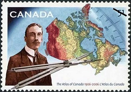 Canada 2006-06-30 (single) On June 30th, 2006, Canada Post will issue a new stamp to mark the 100th anniversary of the National Atlas of Canada. The new stamp shows geographer James White (1863 – 1909) who is considered to be the father of what become The Atlas of Canada. The stamp was issued on June 30, 2006 but was unveiled Monday June 19th at the GeoTec/CCA conference in Ottawa. You can read more about the stamp in the Canada Post press release, and in the archived Natural Resources Canada announcement. The Atlas Celebration web site is also worth a look. The sheet design features two groupings of eight stamps with a number of surrounding mapping and surveying related images. This may well be one of the finest cartophilatelic issues in recent years!
 Canada 2006-06-30 (pane)
|
Welcome to the CartoPhilatelic Society Celebrating our 67th Year as a Society. Come and Join Us!
The CartoPhilatelic Society has entered our 68th year as a Society! In 1955 a group of philatelists with a keen interest in map stamps founded the CartoPhilatelic Society. Today we carry on their passion for map stamps in the collections we assemble and the research we conduct.
Come and join us as we look forward to the future!
Web Site Last Updated:
July 24, 2023
Our Visitors Map Updated 2015-09-21. Thanks to all 19941 unique visitors!

A one year term of membership for the CartoPhilatelic Society runs April 1 through
March 31. Unless you have pre-paid for multiple years, or renewed you dues, your membership has expired at the end of March 2023
If you have not yet paid, please continue to support the Society and renew your dues for the forth-coming term (April 2023 through March 2024) as soon as possible.

A big "Thank You!" to all those members who have recently renewed their membership! The CPS appreciates your continued support and donations.
Visit our Membership page for information.
|
|
 CPS Resource Centre