Swiss Post released a set of three mini-sheets making the bicentenary of the cantons of Geneva, Neuchatel and Valais joining the Swiss Confederation.
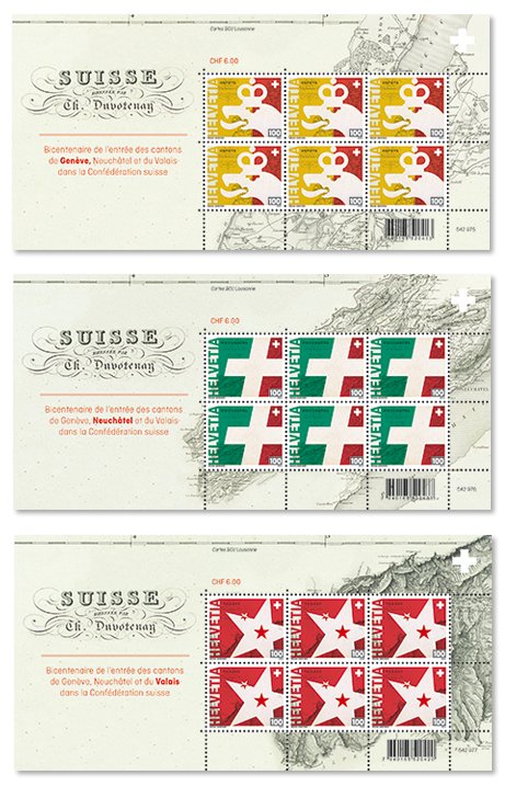 Switzerland 2015-05-07 The sheets issued on May 7, 2015 depict stylized images of the flags of the three cantons set in a 2 x 3 block of stamps. On the right hand portion of the sheets, three unique maps surround the stamps in the background of each of the sheets.
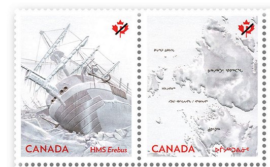 Canada 2015-08-06 On August 6, 2015 Canada Post released a set of stamps marking the 2014 discovery of the remains of HMS Erebus, one of two ships from Sir John Franklin’s ill-fated 1840’s journey in search of the Northwest Passage. A number of formats of the issue exist. On the pane of 16 stamps, set in two columns with a red seal bearing Franklin’s portrait in gutter, are eight pairs of se-tenant domestic stamps. The left stamp depicts the HMS Erebus encased in ice, while the right stamp shows a map of the Arctic region where the expedition perished. Text in the gutter of the pane and locations on the map are written in Inuktut, a tribute to the stories of Inuit eyewitnesses, passed down through oral accounts which helped pinpoint the discovery of the remains. A single-stamp, international rate ($2.50) mini-sheet was also issued. The main background image of the mini-sheet shows an underwater photo depicting the finding of Erebus’ bell. This is overlaid by a a map of the region where the expedition perished. The international stamp on the mini-sheet features a sonar image of HMS Erebus with a line drawing of the ship’s main deck. A booklet, featuring 10 stamps from the domestic pane was also issued. The background on the booklet sheet appears to be a different smaller scale map of the area.
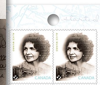 Canada 2015-07-10  In addition to the Franklin Expedition issue, on July 10, 2015 Canada Post released a booklet of 10 self-adhesive domestic Permanent “P” denominated stamps honoring Canadian author and Nobel Prize winner Alice Munro. While there is no map on the actual stamp, a slightly visible map is shown in the upper left corner of the booklet pane. The main design of the issue features a photograph of Ms. Munro taken by her daughter Sheila. Regarding the rest of the design Canada Post describes as containing “a sample of Munro’s handwriting from archival material, and vintage images of Wingham, Ontario, the author’s birthplace and the stamp’s cancel site.” Perhaps the map is from that area, additional information would be helpful. Ms. Munro’s second husband, Gerald Fremlin, was a cartographer and geographer, so possibly the map design has a connection there too. In addition to the Franklin Expedition issue, on July 10, 2015 Canada Post released a booklet of 10 self-adhesive domestic Permanent “P” denominated stamps honoring Canadian author and Nobel Prize winner Alice Munro. While there is no map on the actual stamp, a slightly visible map is shown in the upper left corner of the booklet pane. The main design of the issue features a photograph of Ms. Munro taken by her daughter Sheila. Regarding the rest of the design Canada Post describes as containing “a sample of Munro’s handwriting from archival material, and vintage images of Wingham, Ontario, the author’s birthplace and the stamp’s cancel site.” Perhaps the map is from that area, additional information would be helpful. Ms. Munro’s second husband, Gerald Fremlin, was a cartographer and geographer, so possibly the map design has a connection there too.
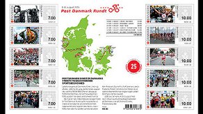 Denmark 2015-06-27 Saluting the “Tour of Denmark” bicycle race, Denmark Post issued a sheet of stamps marking the 25th anniversary of the race. The June 27, 2015 issue features 10 franking labels. The images feature highlights from the history of the race, including some of the winners. In the center of the sheet is a map of Denmark showing the route. The sheet includes five franking labels with a denomination of DKK 7.00, and five franking labels with a denomination of DKK 10.00.
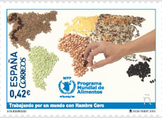 |
| Spain 2015-06-04 |
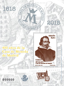 |
| Spain 2015-06-17 |
In two recent issues from Spain Post, the first on June 4, 2015 is a single EUR 0.42 denomination stamp dedicated to the World Food Program (WFP). The stamp depicts a world map made from food producing seeds a hand placing the seeds. Spain Post describes the dual symbolism of the image: on the one hand, WFP is working for a hunger-free world by providing the production necessary for universal provision and, at the same time, it is the hand that picks the food needed. The second issue on June 17, 2015 marks the 400th anniversary of the Mint of Madrid. The Mint of Madrid was founded by a Royal Decree from Felipe III on 18 February 1614. The mini-sheet includes a EUR 3.23 stamp with the portrait of the Duke of Uceda, the first director of the Mint. In the background, is what appears to be an oblique aerial view of the city streets and buildings surrounding the Mint, with the Mint building appearing at the bottom of the sheet. [better images on these two Spanish issues are needed. -admin]
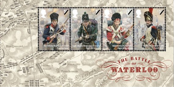
On June 18, 2015, UK’s Royal Mail will issue a set of memorial stamps marking the 200th anniversary of the Battle of Waterloo. Of interest to CartoPhilatelists are two mini-sheets depicting battle field maps. The first mini-sheet is issued in conjunction with the stamp set. This 146mm x 74mm mini-sheet contains four joined single stamps in the upper right of the sheet. There are two UK “first-class” stamps depicting a Prussian Infantryman and a Light Infantry member of the King’s German Legion. The remaining two stamps are a £1.33 and depict soldiers of the 92nd Gordon Highlanders and French Imperial Guard Grenadier, respectively.
 GB 2015-06-18 Battle of Waterloo (mini-sheet) The second mini-sheet containing a map is actually from one of the four panes from the Prestige Booklet for the issue. “The 24-page booklet explores the political background to the conflict as well as offering an hour by-hour account of how the battle unfolded. It also includes all ten stamps from the issue in unique combinations. “ Pane 3, containing the remaining two first-class values from the Battle of Waterloo set, features a detailed battlefield map engraving showing the strategic positioning of the Allied, Prussian and French forces.
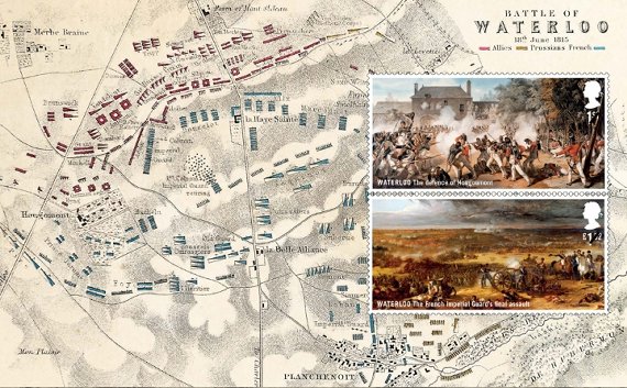 GB 2015-06-18 Pane-3 Prestige Booklet – Battle of Waterloo
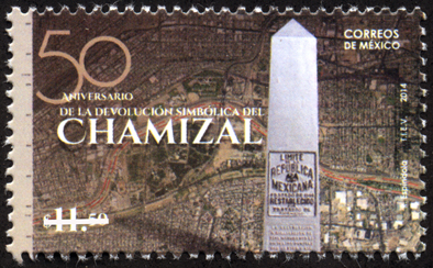 Mexico 2014-09-30 On September 30th, 2014 Mexico Post issued a new stamp marking the 50th anniversary of the finalization of the Chamizal Resolution, a border dispute between the USA and Mexico which persisted in one form or another for more than a 100 years. The 11.50 Peso issue symbolizes the return of the Chamizal to Mexico. While the treaty that ended the dispute was formally settled on 14 January 1963, the final ceremony marking the border adjustment took place on September 25, 1964, where U.S. President Lyndon B. Johnson and Mexican President Adolfo López Mateos were present to unveil the new boundary marker signaling the peaceful end of the Chamizal dispute. The new issues features what appears to be an aerial photo of the disputed Cordova island area along the Rio Grande near El Paso, Texas, and Ciudad Juárez, Chihuahua, Mexico. In the foreground of the stamp, the boundary monument is shown. In 1966, Congress established the Chamizal National Memorial to commemorate the Chamizal Convention (treaty) of 1963.
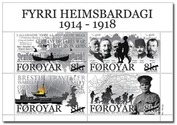 Faroe Islands 2014-09-24 World War I On September 24, 2014, Faroe Islands Post announced two new issues, both of which are of cartophilatelic interest. The first, a four stamp souvenir sheet marks the centenary of the start of World War I and involvement of the Faroe Islands, while the second, a single stamp, commemorates the life and achievements of preacher and missionary Daniel Jacob Danielsen, popularly referred to as “Dollin.” The First World War Centenary mini-sheet consists of a two x two block of four DKK 8.0 stamps with unique images, three of which appear to contain maps. The postal authority web site contains a very detailed writeup of WW I events relating to the Faroe Islands and depicted by the stamps.
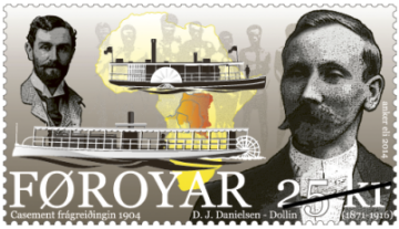 Faroe Islands 2014-09-24 Casement Report The single DKK 25.00 stamp depicts portraits of both Dannielsen and Roger Casement along with two river paddle ships, and a map of the African continent showing the Congo Free State as it was known at the time. Dannielsen worked as a missionary in Congo arriving there in 1901 and working on the paddle ship “Pioneer” the upper vessel shown on the stamp. From the 1890’s, there had been stories of atrocities against the indigenous people of the Congo Free State. Missionaries, journalists and a human rights organization reported about large-scale violation of human rights, but they were ignored by the administration in Congo. As these stories became more widespread, the English Parliament decided in 1903 to send the British consul in Boma, Congo, Roger Casement, up the Congo River to investigate the allegations. Continue reading Recent Faroe Islands Issues Feature Maps
 Switzerland, 2014-09 |
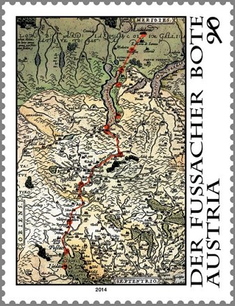 Austria, 2014-09 (forthcoming) |
Update: We received an image from Volker Woesner, our European Representative, of the forth-coming (late September) issue from Austria. The very striking issue appears to be totally comprised of an Ortelius map from 1587, (shown here) The Lindau coach mail route is also depicted on the map, with north being at the bottom, the route shown is from Lindau “south” into Italy.
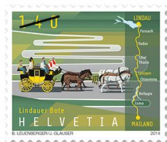
In September 2014, the postal authorities of Austria, Germany, Lechtinstein, and Switzerland will release a joint issue commemorating the “Lindau Messenger” mail service. From the Swiss Post web site, “the first recorded delivery by the Lindau Messenger took place in the early 16th century, although the messenger had been running since the 14th century. The era of the Lindau Messenger came to an end when a completely new generation of roads were built over the main Alpine passes, allowing stagecoaches to cross them, which made traveling easier and safer and the messenger service superfluous.” While final details in English have not been easy to find, at this time it appears that issues of Austria and Switzerland will have maps incorporated into their designs. The Swiss issue similar has a route map on the right side of the stamp, with a mail carriage shown in the remaining section of the design. A special book with the stamps appears to be available from Swiss Post. [ we will update this post when more information is available – admin ]
On July 21, 2014, the Bahamas Postal Service released a new set of stamps commemorating the 10th anniversary of the establishment of the Bahamas National Geographic Information Systems (BNGIS) Center. The Center was founded on July 26, 2004. The set of four stamps feature denominations of 15c, 50c, 65c and 70c. The stamps feature various paper and digital maps and photographs of technicians surveying in the field. The mission of the BNGIS is to promote, educate, coordinate and advance both the practical and efficient use of GIS in the Bahamas. The 15c stamp shows the delineation of the maritime boundaries of the islands, which was finalized in 2008, which are a critical part of territorial sovereignty. The Bahamas archipelago is comprised of 700 atolls, cays and rocks with a total land area of 15107 sq.km which extends over 259,000 sq. km. of shallow banks and ocean area. A thematic map of Hurricane Distribution from 1960 – 2012 is depicted on the 50c stamp. The 65c stamp shows technicians from the BNGIS, working with the members of the Royal Bahamas Defence Force conducting a field verification to check the accuracy of specific the base points used to create the maritime baseline. What appears to be a digital level or total-station is shown in the foreground of the stamp. The 70c stamp depicts a technician, in the foreground, with a GPS field recorder and an aerial photo, in the background, of a neighborhood with road center lines, on Inagua island where field data collection and verification were carried out. The colorful set of stamps also features the BNGIS logo on each stamp. This is the second issue of 2014 which features new data collection technologies and screen images of GIS/computer mapping software. [ please let us know of any other recent GIS related stamp issues – admin ]
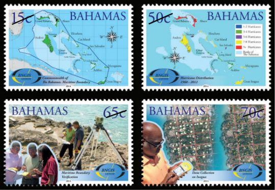 Bahamas, 2014-07-21
|
Welcome to the CartoPhilatelic Society Celebrating our 67th Year as a Society. Come and Join Us!
The CartoPhilatelic Society has entered our 68th year as a Society! In 1955 a group of philatelists with a keen interest in map stamps founded the CartoPhilatelic Society. Today we carry on their passion for map stamps in the collections we assemble and the research we conduct.
Come and join us as we look forward to the future!
Web Site Last Updated:
July 24, 2023
Our Visitors Map Updated 2015-09-21. Thanks to all 19941 unique visitors!

A one year term of membership for the CartoPhilatelic Society runs April 1 through
March 31. Unless you have pre-paid for multiple years, or renewed you dues, your membership has expired at the end of March 2023
If you have not yet paid, please continue to support the Society and renew your dues for the forth-coming term (April 2023 through March 2024) as soon as possible.

A big "Thank You!" to all those members who have recently renewed their membership! The CPS appreciates your continued support and donations.
Visit our Membership page for information.
|
|
 CPS Resource Centre