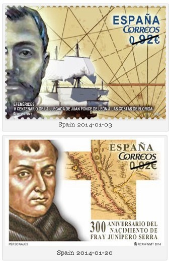
 Spanish Post started 2014 out with two issues of interest to fellow CartoPhilatelists. The first issue, of January 3rd, 2014, marks the fifth centenary of the arrival of Juan Ponce de León to the coast of Florida. On Easter Sunday 1513, also called Pascua Florida (the Festival of Flowers), the Spanish expedition led by Juan Ponce de León discovered a new land which they named Florida, in honor of the day’s religious festival. The self adhesive issue has a denomination of 0,92 €. The stamp depicts a partial portrait of the explorer on the left of the design along with a sailing ship. What appears to be a nautical chart with a partial compass rose and possibly islands on the chart is shown in the background of the issue. The second issue, of January 20, 2014, commemorates the 300th anniversary of the birth of Franciscan friar Junípero Serra. In 1749, Friar Serra was sent with other Franciscans to New Spain, now Mexico, where he was a missionary, preaching the gospel in various parts of the country. In 1768 when the Jesuits were expelled from New Spain, Friar Serra and other monks were sent to Lower and Upper California to found a range of missions reaching up to the bay of San Francisco in the USA. Over the years, these missions became important cities, such as San Diego, Los Angeles, San Francisco and Sacramento. Friar Serra was beatified in 1988 by Pope John Paul II. The 0.92 € denomination stamp features a portrait of Friar Serra and an antique map showing Baja California cut into the shape of a cross. Spanish Post started 2014 out with two issues of interest to fellow CartoPhilatelists. The first issue, of January 3rd, 2014, marks the fifth centenary of the arrival of Juan Ponce de León to the coast of Florida. On Easter Sunday 1513, also called Pascua Florida (the Festival of Flowers), the Spanish expedition led by Juan Ponce de León discovered a new land which they named Florida, in honor of the day’s religious festival. The self adhesive issue has a denomination of 0,92 €. The stamp depicts a partial portrait of the explorer on the left of the design along with a sailing ship. What appears to be a nautical chart with a partial compass rose and possibly islands on the chart is shown in the background of the issue. The second issue, of January 20, 2014, commemorates the 300th anniversary of the birth of Franciscan friar Junípero Serra. In 1749, Friar Serra was sent with other Franciscans to New Spain, now Mexico, where he was a missionary, preaching the gospel in various parts of the country. In 1768 when the Jesuits were expelled from New Spain, Friar Serra and other monks were sent to Lower and Upper California to found a range of missions reaching up to the bay of San Francisco in the USA. Over the years, these missions became important cities, such as San Diego, Los Angeles, San Francisco and Sacramento. Friar Serra was beatified in 1988 by Pope John Paul II. The 0.92 € denomination stamp features a portrait of Friar Serra and an antique map showing Baja California cut into the shape of a cross.
[CartoPhilatelists will recognize previous issues of these themes namely USA sc2024 for Ponce de Leon, and then Spain sc2394 and USA scC116 for Friar Serra. If there are others, please tell us. In addition, the Spanish Post web site mentioned that the January 20, 2014 issue also was for Pedro Cieza de León, explorer and chronicler of the Indies. however I could not determine if there was an additional stamp or not Update: Julien from France informs us that there is a separate issue for Pedro Cieza de León however it does not have a map. Thanks! -admin]
 Belgium 2013-06-24 Fellow map stamp collector Julien writes from Europe to inform us of a very interesting and hidden map on the June 26, 2013 issue from Belgium Post which marks the 100th anniversary of the Belgium Royal Meteorological Institute and their forecasting of the weather. The souvenir sheet shown below contains five stamps. Along the top edge of the sheet are a series of weather condition icons. The foreground of the sheet is covered by a large grassy hill, and in upper center is a single stamp which depicts the institute’s headquarters located in Uccle. On the right side of the sheet is a researcher with a weather balloon and standing near an instrument station. Arranged along the bottom of the sheet are four evenly sized rectangle stamps depicting a tree with green foliage. Around the trees, in the background of each stamp, are weather conditions marking each of the four seasons, spring, summer, autumn and winter. Julien tells us that the hidden map can be found in the shape of the trees represent the outline of Belgium, rotated slightly counter-clockwise. However, there is another interesting point about this sheet. When you press your finger on each of the trees, or when the temperature is more than 77F (25C) the foliage of the trees will be transformed to a seasonal color and each tree will have a series of small images representing a common daily forecasts for each season visible in the leaves. This is shown in the image below. [ Thanks Julien for alerting us to this very important cartophilatelic issue! We know of one other map sheet from Iceland (sc1162) issued in 2009 for the International Polar Year which has a similar heat triggered coating, does anyone know of any others? — web admin ]
") Detail of Belgium 2013-06-24 with temperature above 77F (25C)
 Iceland 2013-09-12 On September 12, 2013 Iceland Post issued a new stamp to mark the 50th anniversary of the emergence of the volcanic island Surtsey. The stamp does not outwardly show a denomination, but the face value of a single stamp is ISK 565 (approx USD 4.70) appears to be valid for domestic service up to 1500 grams. The stamp is issued in sheets of ten, with two rows containing five stamps. Having a fascinating history, Surtsey island emerged from the ocean on November 14, 1963 in a volcanic eruption that continued until June 1967. At its largest the area of the island was about three sq.km., however it has been eroded by ocean waves and is now only about half of its initial size. A diverse amount of vegetation can be found on the island which now resembles its neighboring islands. The island is a model site for biocolonisation research. The island is rich in bird life with fulmars, black guillemot, gulls, puffins and other bird species. In 2008, Surtsey island was designated as a UNESCO World Heritage Site.
 This sheet which we introduced a few months ago is now available on the USPS.com web site for pre-order. A special $US 200 Inverted Jenny Collector’s Edition is also available for pre-order. This sheet which we introduced a few months ago is now available on the USPS.com web site for pre-order. A special $US 200 Inverted Jenny Collector’s Edition is also available for pre-order.
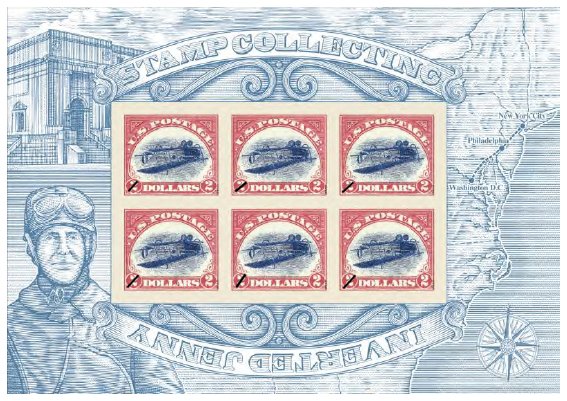
On September 22, 2013, the USPS is planning to issue a souvenir sheet with a re-designed Jenny Invert to commorate the opening of the Smithsonian’sNational Postal Museum opening of the William H. Gross Stamp Gallery — the world’s largest stamp gallery. This souvenir sheet features a new version of the most famous error in the history of U.S. stamps: the Inverted Jenny, a 1918 misprint that mistakenly showed a biplane flying upside down. Reprinted with a $2 denomination to make them easily distinguishable from the 24-cent originals, the Inverted Jennys on this sheet commemorate the many ways a single stamp can turn a moment in history upside down. The original engraved dies to produce the 1918 Inverted Jenny are being used in the design to produce the new stamps. In current press-release images, “the right side of the souvenir sheet shows a map of the northeastern United States that focuses on the route of the first regularly scheduled Air Mail service in May 1918. A compass rose, a common element on maps and nautical charts, appears in the lower right corner.”
The Philatelic Bureau of San Marino is planning to issue a new souvenir sheet on June 7, 2013 that commemorates the 550th anniversary of the determination of borders between the Republic of San Marino and Italy. A proposed joint issue with Italy, the € 5.45 sheet depicts two regions prior to the “Patti di Fossombrone” (Pacts of Fossombrone) when in 1463 San Marino obtained the castles of Montegiardino, Fiorentino, Serravalle and Faetano resulting in the territorial borders that still exist today. The souvenir sheet contains four stamps in horizontal orientation. The background of the sheet shows the papal decree by which His Holiness Pius II ratified the “clauses of the previous agreements between San Marino and the papal legate Cardinal. ”
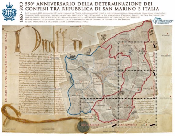 San Marino (forthcoming 2013-06-07) 550th anniversary of the determination of borders with Italy.
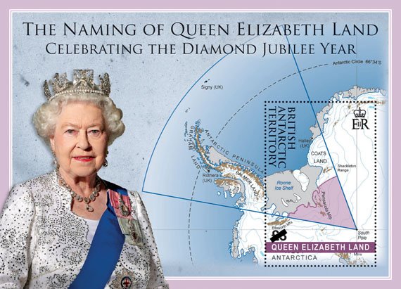 Queen Elizabeth Land, 2013-02 Announcement, status unknown New issue sleuth Mark Honig has alerted us to this supposed Feb 2013 issue from British Antarctic Territory marking the appellation of “Queen Elizabeth Land” last December 18th, 2012 by the British Foreign and Commonwealth Office. This rough image depicts on the right of the sheet, a map of the newly named territory with a photo image of HM Queen Elizabeth II on the left. The sheet honors the Queen in her Diamond Jubilee Year. We are uncertain of the status of this sheet. The Foreign and Commonwealth Office has indicated that the name “Queen Elizabeth Land” will be used in future on all British maps, however due to the unique status of Antarctica, as stated in the Antarctic Treaty, it will be up to other countries to recognize the name if they so choose. If anyone has any additional information about this issue, please contact Mark Honig
|
Welcome to the CartoPhilatelic Society Celebrating our 67th Year as a Society. Come and Join Us!
The CartoPhilatelic Society has entered our 68th year as a Society! In 1955 a group of philatelists with a keen interest in map stamps founded the CartoPhilatelic Society. Today we carry on their passion for map stamps in the collections we assemble and the research we conduct.
Come and join us as we look forward to the future!
Web Site Last Updated:
July 24, 2023
Our Visitors Map Updated 2015-09-21. Thanks to all 19941 unique visitors!

A one year term of membership for the CartoPhilatelic Society runs April 1 through
March 31. Unless you have pre-paid for multiple years, or renewed you dues, your membership has expired at the end of March 2023
If you have not yet paid, please continue to support the Society and renew your dues for the forth-coming term (April 2023 through March 2024) as soon as possible.

A big "Thank You!" to all those members who have recently renewed their membership! The CPS appreciates your continued support and donations.
Visit our Membership page for information.
|
|
 CPS Resource Centre