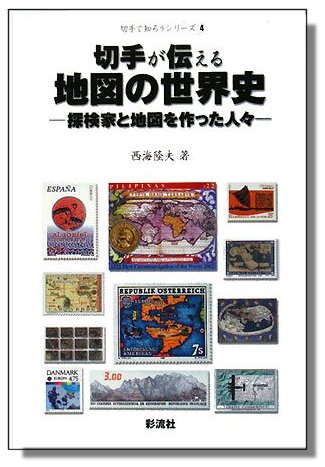
GSM July 2015, N. Davenhill, “On the Map – Or Perhaps Not!” The July 2015 issue of Gibbons Stamp Monthly features a richly illustrated cartophilatelic article by Noel Davenhill entitled On the Map — or Perhaps Not! The five page article “charts a course around the Commonwealth to seek out examples issued by Britain’s former colonies, dependencies and protectorates” examining a number of important map stamps prior to 1970. The author begins in the Mediterranean, looking at the 1928 issue from Cyprus and then “travels” south on the African continent, examining some of the early Commonwealth issues, mentioning a number of interesting facts. Leaving Africa, the Caribbean is the next stop, providing details about issues from Barbuda, the British Virgin Islands and Anguilla. After a brief stop in South America to examine issues from British Guiana, the article examines a number of important issues from commonwealth members in the Pacific. Moving to South East Asia, the article contrasts the differences in issues from North Borneo. Next stop is the Indian Ocean where the author highlights coordinate errors on an early Mauritius issue and also notes positional discrepancies on early Seychelles issues. The article ends in the South Atlantic with a comparison of the issues from Tristan da Cunha, Saint Helena, the Falklands and their dependencies. [with thanks to CPS President Mark Honig for the first page image and written description; member Tom H. from Norway tells us that there is a Gibbons Stamp Monthly as an Apple app, downloadable from the app store, where you can buy a single issue, approx USD 6 USD or possible to subscribe. The article is on page 124. Thanks Tom! – admin]
 T. Nishiumi, “World History of Maps – Explorers and Map Makers,” 2008 A foreign cartophilatelic reference has recently been brought to our attention. A Japanese book entitled World History of Maps: Explorers and Map Makers by Mr. T. Nishiumi was published in 2008. Mr. Nishiumi won a Large Vermeil at Brasiliana 2013, with a score of 89 points. The book, written in Japanese, contains concise text and superb full-color reproductions of over 400 stamps. The subject matter and selection of the states are based on exhibits prepared by the author, many of which have won international Silver and Gold Awards. As the instructional value of Nishiumi’s book is of merit for those who contemplate the preparation of similar exhibits or the compilation of a related collection, a comprehensive checklist of the illustrated stamps has been prepared. This page-by-page inventory, is separated by the chapter titles translated into English and follows the style of our Maps on Stamps (MoS) Checklist. The list may also be used as a reading guide for those who decide to purchase the book. The list is available as an Excel spreadsheet for download. Those who wish to purchase the book outside Japan can use the Kinokuniya web site.
 New Caledonia sc651 |
 New Caledonia scC275 |
 China sc3031 |
 South Korea sc1516 |
Cartophilatelic Society president Mark Honig informs us of finding some previously unknown map stamps. First up is the 170fr August 26, 1991 issue from New Caledonia for the French Institute of Scientific Research (sc651). A number of research themes are depicted on this very colorful stamp. In the center is a stereo or dissecting microscope and on the stage of the microscope is a map of New Caledonia. Definitely a hidden map! The next newly discovered map stamp also comes from New Caledonia. The 130fr airmail issue of July 20, 1996 marks the Indonesian Centenary (scC275). The stamp depicts a man and woman dressed in traditional Indonesian attire. Behind the couple is a tree. In the branches and leaves of the tree, the islands of the Indonesian Archipelago can be seen. A very interesting and uniquely designed map stamp. From the South Pacific we move to North Asia. Here, the first newly discovered map stamp is from the June 1, 2000 “Stampin’ the Future” children’s stamp design issue (sc3031). The 60f denomination stamp features an image of a young girl in front of a computer screen which depicts a map of China and Taiwan and a “bridge being constructed” across the South China Sea between China and Taiwan. The next discovery is from South Korea (sc1516), with the 80w October 8, 1988 issue marking the 22nd Congress of The International Iron and Steel Institute, that we assume was held in Seoul about that time. This thematic stamp depicts a large foundry ladle in a steel mill pouring out molten metal. A world map with a very interesting looking projection is shown on the side of the ladle. For our final discovery we move to the Netherlands and a personal note from Mark regarding the next newly discovered map stamp. Mark writes, when I was browsing ebay for map stamps I noticed this stamp with what looks like a small map. I immediately knew I must have this stamp because it is a stamp from my own country. I pulled my album and I scanned for the stamp. This stamp has been issued, as part of a set of 4, to commemorate the 40th anniversary of the liberation for the Netherlands from nazi-Germany in 1945. The detail shown in the map is part of a newspaper, “The Flying Dutchman,” air-dropped by the Allied Air Forces, and shows the Russian front advancing from Tarnopol to Cherzon. After a bit of searching I found the map was shown on the cover of the March 16, 1944 issue. I’m a bit embarrassed to admit that this stamp has been in my album for 28 years without me noticing it as a map stamp. The stamp (and set) are not expensive. The stamp has also been issued as a coil stamp. These coil stamps can be recognized by the cut perforations along the top and bottom. Mint coils have a number on the back of every 5th stamp. Perhaps now is the time to check your own collections for more hidden map stamps, you never know what may be hiding there. Please let us know what you find!
 Netherlands sc666 |
 “The Flying Dutchman,” March 16, 1944 |
 Earlier in the spring of 2012, Mark Honig, our Society’s then vice-president wrote an introductory article entitled “Landkaarten op postzegels” that appeared in the April 2012 issue of the Dutch philatelic magazine “Thema,” published by NEDERLANDSE VERENIGING VOOR THEMATISCHE FILATELIE (NVTF) [The Dutch Society for Thematic Philately]. NVTF is the only general thematic philatelic society in the Netherlands with over 800 members. Earlier in the spring of 2012, Mark Honig, our Society’s then vice-president wrote an introductory article entitled “Landkaarten op postzegels” that appeared in the April 2012 issue of the Dutch philatelic magazine “Thema,” published by NEDERLANDSE VERENIGING VOOR THEMATISCHE FILATELIE (NVTF) [The Dutch Society for Thematic Philately]. NVTF is the only general thematic philatelic society in the Netherlands with over 800 members.
NVTF has graciously allowed Mark to produce a revised translation of the original version of the article and we are very happy to offer it here, for download:
Maps on Stamps Introduction Article 2012
. You wont want to miss this detailed and colorful introduction to the various categories that await the new carto-philatelic collector. [The Carto-Philatelic Society wishes to thank NVTF for allowing this article to be translated and reach a wider audience. ]
“Atlas of Vatican CartoPhilately” Article Series Now Available
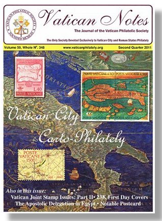 In late 2011 we learned of a series of articles about Vatican CartoPhilately published in Vatican Notes. These articles were written by James Hamilton, a member of the Vatican Philatelic Society and a recent new member of our Society. The thrid article in the series has been published and we have obtained permission from James and the Vatican Philatelic Society to make that series available for download on our web site. The articles provide an indepth look at cartophilatelic issues from the Vatican. James has begun another series of articles entitled, “Captain James Cook CartoPhilately” that will be published in The New CartoPhilatelist. In late 2011 we learned of a series of articles about Vatican CartoPhilately published in Vatican Notes. These articles were written by James Hamilton, a member of the Vatican Philatelic Society and a recent new member of our Society. The thrid article in the series has been published and we have obtained permission from James and the Vatican Philatelic Society to make that series available for download on our web site. The articles provide an indepth look at cartophilatelic issues from the Vatican. James has begun another series of articles entitled, “Captain James Cook CartoPhilately” that will be published in The New CartoPhilatelist.
In recent issues of Vatican Notes, the official journal of the Vatican Philatelic Society, there have been two in-depth articles on Vatican CartoPhilately. The articles, are written by James Hamilton, a member of the Vatican Philatelic Society and also a new member of our Society. James is also an Arago volunteer who has written numerous articles on Vatican City philately. In a recent interview on the Arago web site, James recalls his childhood interest in stamps and how he “quickly became interested in stamps from Europe and used an atlas to locate the issuing countries, thereby learning geography as well.” A similar view, perhaps held by many fellow cartophilatelists. Later in the interview, James mentions that Arago’s online exhibit of “Allan Lee’s Maps on Stamps Volume 6 was spectacular.” Jame’s article “Atlas of Vatican City Carto-philately” is divided into three parts. Part one considers maps on stamps or postal cards of the world Europe and Italy. Part two looks at maps of the Western Hemisphere, Africa the Near and Far East. Part Three considers topographical maps, historical travels on maps and outlines of continents or count ires on stamps. Part one was published in Second Quarter 2011, Vol. 59, No. 348, and Part two in Third Quarter 2011, Vol. 59, No. 349 of Vatican Notes. We will have an update once the third part in the series has been published.
|
Welcome to the CartoPhilatelic Society Celebrating our 67th Year as a Society. Come and Join Us!
The CartoPhilatelic Society has entered our 68th year as a Society! In 1955 a group of philatelists with a keen interest in map stamps founded the CartoPhilatelic Society. Today we carry on their passion for map stamps in the collections we assemble and the research we conduct.
Come and join us as we look forward to the future!
Web Site Last Updated:
July 24, 2023
Our Visitors Map Updated 2015-09-21. Thanks to all 19941 unique visitors!

A one year term of membership for the CartoPhilatelic Society runs April 1 through
March 31. Unless you have pre-paid for multiple years, or renewed you dues, your membership has expired at the end of March 2023
If you have not yet paid, please continue to support the Society and renew your dues for the forth-coming term (April 2023 through March 2024) as soon as possible.

A big "Thank You!" to all those members who have recently renewed their membership! The CPS appreciates your continued support and donations.
Visit our Membership page for information.
|
|
 CPS Resource Centre