 Guernsey and Alderney, 20140730 Guernsey Post’s July 30th, 2014 issue from Alderney commemorating the life of British espionage author Ian Fleming features a “somewhat hidden” map. The set is comprised of six self-adhesive stamps, featuring black and white photographs of Fleming at various times during his lift. Denominations of the issue are 41p, 54p, 55p, 66p, 74p, and 83p. Also available is a £3 miniature sheet, and features Fleming driving a car resembling the one in his story, “Chitty Chitty Bang Bang.” The hidden map is shown here on the 54p stamp. Fleming is shown in the foreground with a map of the world on the wall behind him. Centered on the Pacific Ocean, Australia, New Zealand, the island of New Guinea are on the left, and South America on the right are all clearly visible on the map. An inscription reads, “The Life of Ian Fleming – Well traveled, he wrote vividly about the places he visited. ” The set of six singles are also available in sheets of ten, which additional descriptive text and images in the margins. From the web site, it was not clear if there are any more maps on the sheets, aside from the 54p issue.
 ATA 65th NTSS 2014 Logo At the American Topical Association’s 65th National Topical Stamp Show (NTSS) [St. Louis Missouri, USA] held in June 2014, The New CartoPhilatelist was awarded the prestigious Gold Medal in the Medium Study Units (50-200 members) class. In addition, TNCP received the Grand Prize as the best of the 10 journals entered in this category. The award was presented at the banquet dinner to our Journal’s editor Mr. Martin Oakes who was joined at the ceremony by Society Vice-President David Wolfersberger and Society President Emeritus Miklos Pinther. “This award is not only proof of Martin’s dedication and effort towards producing each issue, but also the high level of research and attention to detail evident in the articles and content submitted by the authors. This is a wonderful recognition for the Society,” said CPS President Mark Honig. “Congratulations to everyone over the years who have helped put The New CartoPhilatelist on the philatelic literature world map!”
 |
|
 |
Martin Oakes, Editor,
The New CartoPhilatelist
(Gold Medal, 50-200 Members
Study Unit) |
|
Miklos Pinther (L), Single Frame, “Map Stamps That Never Made It,” Silver-Bronze;
David Wolfersberger (R), Editor, Enophilatelica
(Gold Medal, less than 50 members Study Unit) |
 Korea 2014-03-20 On March 20, 2014 Korea Post issued two new stamps depicting a cadastral readjustment project taking place in the country. These fascinating stamps show a myriad of current high-tech devices used for surveying and mapping. The 300₩ stamp features what appears to be a GPS receiver of some type and a rotary aerial drone, whose intended use in this context, is probably aerial photography. In the background is a map graphic of the Korean peninsula. The 390₩ stamp features an Android smartphone, used as a mobile mapping terminal, with a cadastral map on the display showing what may be two different sets of parcel boundaries. In the background is what appears to be an oblique aerial image of an apartment complex overlaid with some vector GIS data depicting cadastral parcel boundaries. Both stamps are issued in the same joint sheet of 20 (4×5) format. A graphic of a satellite is shown in the upper right selvedge of the sheet. [ some geospatial colleagues in the Korean government pointed out this article, in Korean, which describes the project. another article in English was published in August 2013. this is not the first depiction of a smartphone on a stamp however it may be the first time where a map is shown on the display and the device’s intended use is for field-surveying. also, while this is not the first UAV/drone to be depicted on a stamp, we think this is the first time a rotary UAV has been shown on a stamp. we welcome any additional information and discussion on this very unique and timely cartophilatelic issue. — web admin ]
 Portugal 2014-02-24 On February 24, 2014 Portuguese Post issued a souvenir sheet and single stamp to mark the 400th anniversary of the publishing of Fernão Mendes Pinto’s Pilgrimage (Peregrinação). Pinto was a a Portuguese explorer and writer and the work is considered an autobiographical account of his travels and voyages throughout India, Asia and the far east. The Pilgrimage was published posthumously in 1614 and many historians have doubted the truthfulness of his many interesting stories. The €3.00 sheet features a single long stamp. A world map “Mapa do Mundo de Antonio Sanches, 1623” is shown in the background and covers about 70% of the sheet. The lower 30% of the sheet is covered by hand writing of what could be journal entries. The stamp is in the upper right hand section of the sheet, covering the continents of Africa and Asia, as depicted in the antique world map. In the bottom left corner is a sailing ship of the period and in the bottom right corner is the cover page of the Pilgrimage. The single €1.00 issue features some of the same motifs from the sheet, however there is no map.
") USA 2014-04-22 As a very fitting observance of Earth Day, the US Postal Service issued “Sea Surface Temperatures,” a new global forever stamp on April 22, 2014. The circular self-adhesive is valid for the $1.15 international forever rate, and is the second Global Forever issue to be of interest to cartophilatelists. The stamp depicts a representation of sea surface temperatures brightly colored in the ocean areas, while the land masses of north and south America and covered by a natural color satellite mosaic. “The image is one frame in a 1,460-frame animation created from the output of a computer model of Earth’s climate by the National Oceanic and Atmospheric Administration’s Geophysical Fluid Dynamics Laboratory. The full animation shows how the surface temperatures of the oceans vary seasonally and change over time, and how surface ocean currents and eddies transport heat and water around the globe.” While the web site did not describe the data used, the sea surface temperatures could be derived from MODIS Aqua data and the natural color mosaic also MODIS or Blue Marble. [ please contact us if you know the details of the platforms/sensors/data depicted in this stamp –web admin ]
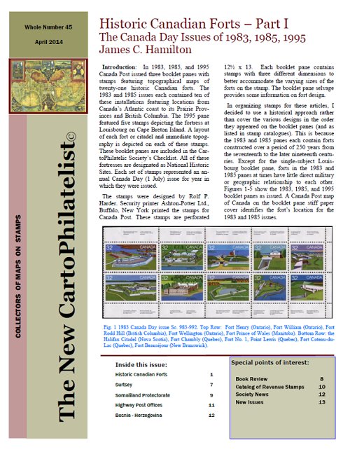
The 45th issue of The New CartoPhilatelist has been dispatched to members. All hard copy members will again be receiving their journals shipped via HP’s MagCloud PoD service. We have decided to continue using MagCloud for both hard copy printing and distribution. The 45th issue is full of fascinating articles, news, and images. Be sure to check out the contents of this exciting issue. Some highlights in this issue are the start of a very interesting issue about the Historic Canadian Forts issues of the 1980’s and 1990’s, by James C. Hamilton. Ap Koopman reports on Surtsey – Iceland’s youngest island and its depiction on a new stamp issue from 2013. President Emeritus Miklos Pinther sends us a book review of Simon Garfield’s “On the Map” and also introduces us to the “Highway Post office” a very unique bit of history of the US Postal Service which operated from 1941 until 1974. Phil Coop introduces us to state revenue stamps from the USA with maps and a new catalog of the State Revenue Society. Ann Kiang Kee sends us a note about Bosnia-Herzegovina and the 20 page issue wraps up with Society News by President Mark Honig, and New Issues and MoS Checklist updates by David Wolfersberger.
|
Welcome to the CartoPhilatelic Society Celebrating our 67th Year as a Society. Come and Join Us!
The CartoPhilatelic Society has entered our 68th year as a Society! In 1955 a group of philatelists with a keen interest in map stamps founded the CartoPhilatelic Society. Today we carry on their passion for map stamps in the collections we assemble and the research we conduct.
Come and join us as we look forward to the future!
Web Site Last Updated:
July 24, 2023
Our Visitors Map Updated 2015-09-21. Thanks to all 19941 unique visitors!

A one year term of membership for the CartoPhilatelic Society runs April 1 through
March 31. Unless you have pre-paid for multiple years, or renewed you dues, your membership has expired at the end of March 2023
If you have not yet paid, please continue to support the Society and renew your dues for the forth-coming term (April 2023 through March 2024) as soon as possible.

A big "Thank You!" to all those members who have recently renewed their membership! The CPS appreciates your continued support and donations.
Visit our Membership page for information.
|
|
 CPS Resource Centre