GSM July 2015, N. Davenhill, “On the Map – Or Perhaps Not!” The July 2015 issue of Gibbons Stamp Monthly features a richly illustrated cartophilatelic article by Noel Davenhill entitled On the Map — or Perhaps Not! The five page article “charts a course around the Commonwealth to seek out examples issued by Britain’s former colonies, dependencies and protectorates” examining a number of important map stamps prior to 1970. The author begins in the Mediterranean, looking at the 1928 issue from Cyprus and then “travels” south on the African continent, examining some of the early Commonwealth issues, mentioning a number of interesting facts. Leaving Africa, the Caribbean is the next stop, providing details about issues from Barbuda, the British Virgin Islands and Anguilla. After a brief stop in South America to examine issues from British Guiana, the article examines a number of important issues from commonwealth members in the Pacific. Moving to South East Asia, the article contrasts the differences in issues from North Borneo. Next stop is the Indian Ocean where the author highlights coordinate errors on an early Mauritius issue and also notes positional discrepancies on early Seychelles issues. The article ends in the South Atlantic with a comparison of the issues from Tristan da Cunha, Saint Helena, the Falklands and their dependencies. [with thanks to CPS President Mark Honig for the first page image and written description; member Tom H. from Norway tells us that there is a Gibbons Stamp Monthly as an Apple app, downloadable from the app store, where you can buy a single issue, approx USD 6 USD or possible to subscribe. The article is on page 124. Thanks Tom! – admin]
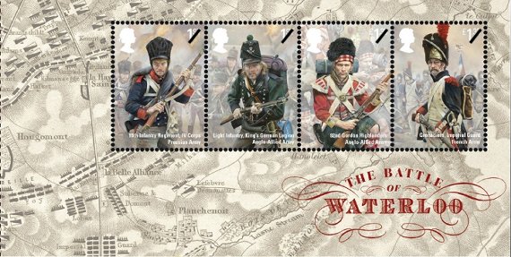
On June 18, 2015, UK’s Royal Mail will issue a set of memorial stamps marking the 200th anniversary of the Battle of Waterloo. Of interest to CartoPhilatelists are two mini-sheets depicting battle field maps. The first mini-sheet is issued in conjunction with the stamp set. This 146mm x 74mm mini-sheet contains four joined single stamps in the upper right of the sheet. There are two UK “first-class” stamps depicting a Prussian Infantryman and a Light Infantry member of the King’s German Legion. The remaining two stamps are a £1.33 and depict soldiers of the 92nd Gordon Highlanders and French Imperial Guard Grenadier, respectively.
 GB 2015-06-18 Battle of Waterloo (mini-sheet) The second mini-sheet containing a map is actually from one of the four panes from the Prestige Booklet for the issue. “The 24-page booklet explores the political background to the conflict as well as offering an hour by-hour account of how the battle unfolded. It also includes all ten stamps from the issue in unique combinations. “ Pane 3, containing the remaining two first-class values from the Battle of Waterloo set, features a detailed battlefield map engraving showing the strategic positioning of the Allied, Prussian and French forces.
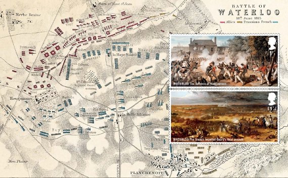 GB 2015-06-18 Pane-3 Prestige Booklet – Battle of Waterloo
The Member’s Only TNCP Archive has been updated with the last three issues. The Table of Contents listings have also been updated. The TNCP Archive is available to current members. Contact the Editor or web admin if you have forgotten the login credentials. [Journal Nos. 47 and No. 48 were dispatched promptly in early October and December. TNCP No. 48 is an expanded issue of 24 pages. Please see the Table of Contents listings for information on these very interesting and richly detailed issues. – web admin]
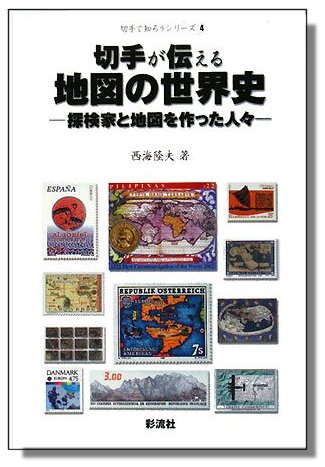 T. Nishiumi, “World History of Maps – Explorers and Map Makers,” 2008 A foreign cartophilatelic reference has recently been brought to our attention. A Japanese book entitled World History of Maps: Explorers and Map Makers by Mr. T. Nishiumi was published in 2008. Mr. Nishiumi won a Large Vermeil at Brasiliana 2013, with a score of 89 points. The book, written in Japanese, contains concise text and superb full-color reproductions of over 400 stamps. The subject matter and selection of the states are based on exhibits prepared by the author, many of which have won international Silver and Gold Awards. As the instructional value of Nishiumi’s book is of merit for those who contemplate the preparation of similar exhibits or the compilation of a related collection, a comprehensive checklist of the illustrated stamps has been prepared. This page-by-page inventory, is separated by the chapter titles translated into English and follows the style of our Maps on Stamps (MoS) Checklist. The list may also be used as a reading guide for those who decide to purchase the book. The list is available as an Excel spreadsheet for download. Those who wish to purchase the book outside Japan can use the Kinokuniya web site.
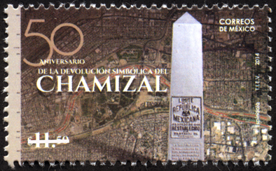 Mexico 2014-09-30 On September 30th, 2014 Mexico Post issued a new stamp marking the 50th anniversary of the finalization of the Chamizal Resolution, a border dispute between the USA and Mexico which persisted in one form or another for more than a 100 years. The 11.50 Peso issue symbolizes the return of the Chamizal to Mexico. While the treaty that ended the dispute was formally settled on 14 January 1963, the final ceremony marking the border adjustment took place on September 25, 1964, where U.S. President Lyndon B. Johnson and Mexican President Adolfo López Mateos were present to unveil the new boundary marker signaling the peaceful end of the Chamizal dispute. The new issues features what appears to be an aerial photo of the disputed Cordova island area along the Rio Grande near El Paso, Texas, and Ciudad Juárez, Chihuahua, Mexico. In the foreground of the stamp, the boundary monument is shown. In 1966, Congress established the Chamizal National Memorial to commemorate the Chamizal Convention (treaty) of 1963.
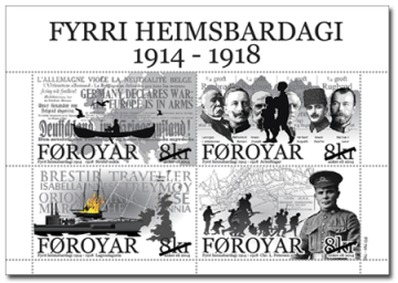 Faroe Islands 2014-09-24 World War I On September 24, 2014, Faroe Islands Post announced two new issues, both of which are of cartophilatelic interest. The first, a four stamp souvenir sheet marks the centenary of the start of World War I and involvement of the Faroe Islands, while the second, a single stamp, commemorates the life and achievements of preacher and missionary Daniel Jacob Danielsen, popularly referred to as “Dollin.” The First World War Centenary mini-sheet consists of a two x two block of four DKK 8.0 stamps with unique images, three of which appear to contain maps. The postal authority web site contains a very detailed writeup of WW I events relating to the Faroe Islands and depicted by the stamps.
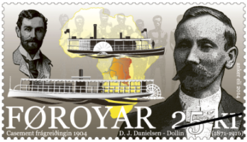 Faroe Islands 2014-09-24 Casement Report The single DKK 25.00 stamp depicts portraits of both Dannielsen and Roger Casement along with two river paddle ships, and a map of the African continent showing the Congo Free State as it was known at the time. Dannielsen worked as a missionary in Congo arriving there in 1901 and working on the paddle ship “Pioneer” the upper vessel shown on the stamp. From the 1890’s, there had been stories of atrocities against the indigenous people of the Congo Free State. Missionaries, journalists and a human rights organization reported about large-scale violation of human rights, but they were ignored by the administration in Congo. As these stories became more widespread, the English Parliament decided in 1903 to send the British consul in Boma, Congo, Roger Casement, up the Congo River to investigate the allegations. Continue reading Recent Faroe Islands Issues Feature Maps
|
Welcome to the CartoPhilatelic Society Celebrating our 67th Year as a Society. Come and Join Us!
The CartoPhilatelic Society has entered our 68th year as a Society! In 1955 a group of philatelists with a keen interest in map stamps founded the CartoPhilatelic Society. Today we carry on their passion for map stamps in the collections we assemble and the research we conduct.
Come and join us as we look forward to the future!
Web Site Last Updated:
July 24, 2023
Our Visitors Map Updated 2015-09-21. Thanks to all 19941 unique visitors!

A one year term of membership for the CartoPhilatelic Society runs April 1 through
March 31. Unless you have pre-paid for multiple years, or renewed you dues, your membership has expired at the end of March 2023
If you have not yet paid, please continue to support the Society and renew your dues for the forth-coming term (April 2023 through March 2024) as soon as possible.

A big "Thank You!" to all those members who have recently renewed their membership! The CPS appreciates your continued support and donations.
Visit our Membership page for information.
|
|
 CPS Resource Centre