 Switzerland, 2014-09 |
 Austria, 2014-09 (forthcoming) |
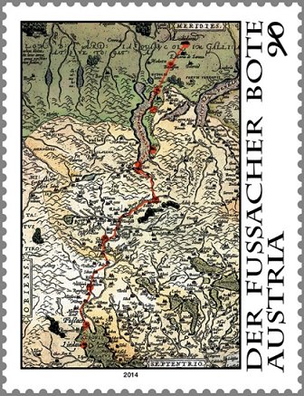
Update: We received an image from Volker Woesner, our European Representative, of the forth-coming (late September) issue from Austria. The very striking issue appears to be totally comprised of an Ortelius map from 1587, (shown here) The Lindau coach mail route is also depicted on the map, with north being at the bottom, the route shown is from Lindau “south” into Italy.
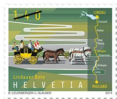
In September 2014, the postal authorities of Austria, Germany, Lechtinstein, and Switzerland will release a joint issue commemorating the “Lindau Messenger” mail service. From the Swiss Post web site, “the first recorded delivery by the Lindau Messenger took place in the early 16th century, although the messenger had been running since the 14th century. The era of the Lindau Messenger came to an end when a completely new generation of roads were built over the main Alpine passes, allowing stagecoaches to cross them, which made traveling easier and safer and the messenger service superfluous.” While final details in English have not been easy to find, at this time it appears that issues of Austria and Switzerland will have maps incorporated into their designs. The Swiss issue similar has a route map on the right side of the stamp, with a mail carriage shown in the remaining section of the design. A special book with the stamps appears to be available from Swiss Post. [ we will update this post when more information is available – admin ]
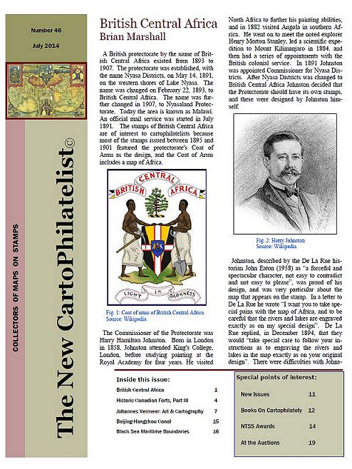
The 46th issue of The New CartoPhilatelist has been dispatched to members. All hard copy members received their journals shipped via HP’s MagCloud PoD service. The46th issue of the Society’s award winning Journal is full of fascinating articles, news, and images. Be sure to check out the contents of this exciting issue. Some highlights in this issue are a very interesting and in depth article by Society Asia/Pacific Representative Brian Marshall on the history of the first postage stamps of the British Central Africa Protectorate. A number of early sets have a subtle but accurate map of the African continent uniquely designed into the Coat of Arms of the Protectorate. The third installment in the series of the Historic Canadian Forts issues of the 1980’s and 1990’s, by James C. Hamilton. Mark Honig reports about the informal CartoSummit that took place in Berlin in early June 2014. David Wolfersberger looks at Art, Cartography and Stamps, through the paintings of Johannes Vermeer. President Emeritus Miklos Pinther take a look at Books on CartoPhilately, with a description of some very interesting non-english works on the subject. Be sure to check out the information on the checklist update of items from T. Nishiumi’s Japanese language book. On pages 14-15 there some images and announcement of the Gold Medal that The New CartoPhilatelist Journal won at the ATA’s 65th National Topical Stamp Show (NTSS) in June 2014. Congratulations to the authors and Martin, our Editor! Member Ang Kian Kee reports about a unique souvenir sheet from China depicting the famous Beijing-Hangzhou Canal, a UNESCO World Heritage Site and the oldest and longest constructed canal in the world. Ap Koopman looks at the interesting and timely topic of Black Sea Maritime Boundaries. Miklos Pinther keeps us informed of some recent auctions of cartophilatelic importance. The issue is rounded out with updates to the MoS checklist, new issue images, a brief notes about the new CPS members email discussion list and dues notices. Unfortunately there was a sad note to report that long time member Ed Stresino passed away in May 2014. Read about Ed’s contributions to our Society over the years. We were fortunate to have had Ed as an active member of the Society. Our condolences to Ed’s wife and family.
On July 21, 2014, the Bahamas Postal Service released a new set of stamps commemorating the 10th anniversary of the establishment of the Bahamas National Geographic Information Systems (BNGIS) Center. The Center was founded on July 26, 2004. The set of four stamps feature denominations of 15c, 50c, 65c and 70c. The stamps feature various paper and digital maps and photographs of technicians surveying in the field. The mission of the BNGIS is to promote, educate, coordinate and advance both the practical and efficient use of GIS in the Bahamas. The 15c stamp shows the delineation of the maritime boundaries of the islands, which was finalized in 2008, which are a critical part of territorial sovereignty. The Bahamas archipelago is comprised of 700 atolls, cays and rocks with a total land area of 15107 sq.km which extends over 259,000 sq. km. of shallow banks and ocean area. A thematic map of Hurricane Distribution from 1960 – 2012 is depicted on the 50c stamp. The 65c stamp shows technicians from the BNGIS, working with the members of the Royal Bahamas Defence Force conducting a field verification to check the accuracy of specific the base points used to create the maritime baseline. What appears to be a digital level or total-station is shown in the foreground of the stamp. The 70c stamp depicts a technician, in the foreground, with a GPS field recorder and an aerial photo, in the background, of a neighborhood with road center lines, on Inagua island where field data collection and verification were carried out. The colorful set of stamps also features the BNGIS logo on each stamp. This is the second issue of 2014 which features new data collection technologies and screen images of GIS/computer mapping software. [ please let us know of any other recent GIS related stamp issues – admin ]
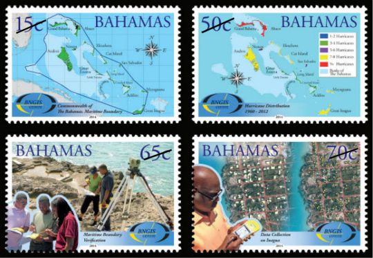 Bahamas, 2014-07-21
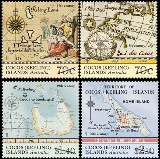 Australia Cocos (Keeling) Islands, 2014-06-24 On June 24, 2014 Austraila Post issued a set of four map stamps depicting the Cocos (Keeling) islands from different periods during the islands’ history. The first European sighting of the Cocos (Keeling) Islands is thought to have been in 1609, by Englishman Captain William Keeling of the East India Company. Soon after, the two atolls that comprise the islands started to appear on maps. The stamps are composed of various maps from a particular century that show the atolls which comprise the Cocos (Keeling) islands. The 70c denomination is a joined pair, featuring maps of the 17th and 18th centuries. From the Australia Post web site, “a number of different maps and navigational charts have been used in the design of the four stamps, including: L’Arcano del Mare (Secrets of the Sea) (1646); Hemisphere oriental ou Ancien Monde (c. 1783); and Karte von dem Morgenlandischen Ocean oder dem Indischen Meere (1758). The single $1.40 denomination features a oceanagraphic chart from the 19th century. The single $2.10 denomination features a topographic map from the 20th century, with what appears to depict a large scale view of “Home Island,” one of the two inhabited islands in the group.
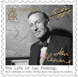 Guernsey and Alderney, 20140730 Guernsey Post’s July 30th, 2014 issue from Alderney commemorating the life of British espionage author Ian Fleming features a “somewhat hidden” map. The set is comprised of six self-adhesive stamps, featuring black and white photographs of Fleming at various times during his lift. Denominations of the issue are 41p, 54p, 55p, 66p, 74p, and 83p. Also available is a £3 miniature sheet, and features Fleming driving a car resembling the one in his story, “Chitty Chitty Bang Bang.” The hidden map is shown here on the 54p stamp. Fleming is shown in the foreground with a map of the world on the wall behind him. Centered on the Pacific Ocean, Australia, New Zealand, the island of New Guinea are on the left, and South America on the right are all clearly visible on the map. An inscription reads, “The Life of Ian Fleming – Well traveled, he wrote vividly about the places he visited. ” The set of six singles are also available in sheets of ten, which additional descriptive text and images in the margins. From the web site, it was not clear if there are any more maps on the sheets, aside from the 54p issue.
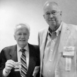
 ATA 65th NTSS 2014 Logo At the American Topical Association’s 65th National Topical Stamp Show (NTSS) [St. Louis Missouri, USA] held in June 2014, The New CartoPhilatelist was awarded the prestigious Gold Medal in the Medium Study Units (50-200 members) class. In addition, TNCP received the Grand Prize as the best of the 10 journals entered in this category. The award was presented at the banquet dinner to our Journal’s editor Mr. Martin Oakes who was joined at the ceremony by Society Vice-President David Wolfersberger and Society President Emeritus Miklos Pinther. “This award is not only proof of Martin’s dedication and effort towards producing each issue, but also the high level of research and attention to detail evident in the articles and content submitted by the authors. This is a wonderful recognition for the Society,” said CPS President Mark Honig. “Congratulations to everyone over the years who have helped put The New CartoPhilatelist on the philatelic literature world map!”
 |
|
 |
Martin Oakes, Editor,
The New CartoPhilatelist
(Gold Medal, 50-200 Members
Study Unit) |
|
Miklos Pinther (L), Single Frame, “Map Stamps That Never Made It,” Silver-Bronze;
David Wolfersberger (R), Editor, Enophilatelica
(Gold Medal, less than 50 members Study Unit) |
|
Welcome to the CartoPhilatelic Society Celebrating our 67th Year as a Society. Come and Join Us!
The CartoPhilatelic Society has entered our 68th year as a Society! In 1955 a group of philatelists with a keen interest in map stamps founded the CartoPhilatelic Society. Today we carry on their passion for map stamps in the collections we assemble and the research we conduct.
Come and join us as we look forward to the future!
Web Site Last Updated:
July 24, 2023
Our Visitors Map Updated 2015-09-21. Thanks to all 19941 unique visitors!

A one year term of membership for the CartoPhilatelic Society runs April 1 through
March 31. Unless you have pre-paid for multiple years, or renewed you dues, your membership has expired at the end of March 2023
If you have not yet paid, please continue to support the Society and renew your dues for the forth-coming term (April 2023 through March 2024) as soon as possible.

A big "Thank You!" to all those members who have recently renewed their membership! The CPS appreciates your continued support and donations.
Visit our Membership page for information.
|
|
 CPS Resource Centre