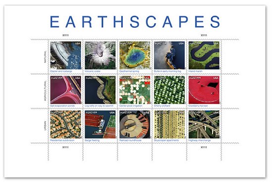
 USA 2012-10-01 On October 1st, 2012, the US Postal Service issued a new sheet of Forever stamps featuring fifteen aerial views of landscapes. Two of the stamps are images from the Landsat 7 satellite. The sheet was released October 1 to kick off National Stamp Collecting Month, and portrays a number of landscapes as viewed from heights of several hundred feet above the Earth to several hundred miles in space. The sheet contains imagery in three categories: natural, agricultural, and urban. The two stamps that feature Landsat images Volcanic Crater and Center-pivot irrigation — depict a natural disaster site, Mount Saint Helens, and an agricultural practice that is common in the Garden City, Kansas area. As part of the Landsat 40th Anniversary Celebration this summer, the USGS and NASA held an online contest in which more 14,000 people voted on their Top Five favorite Earth as Art images.
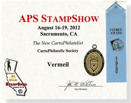
The New Carto-Philatelist Journal has won a Vermeil award at the APS Stamp Show in Sacramento, California that was held from August 16-19, 2012. A very special acknowledgement and round of applause for our Editor, Mr. Martin Oakes, and for all of the authors who have worked so hard to support TNCP every issue! The Society has also entered TNCP at the CHICAGO-PEX 2012 that will
take place from
November 16-18, 2012.
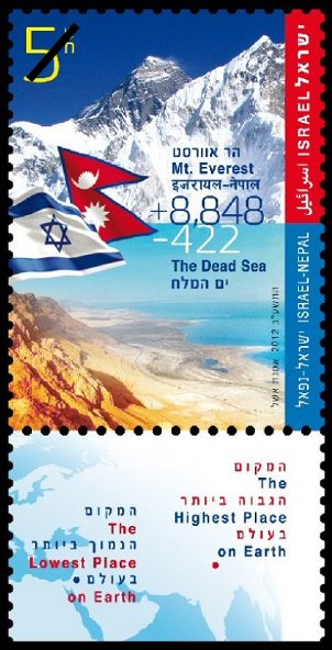 Israel 2012-09 In September 2012, Israel Post released a joint issue with Nepal Post marking full diplomatic relations established between the two countries in 1960. The issue depicts the two elevation extremes on the Earth. The highest, Mount Everest, in Nepal at 8,848 meters above sea level, and the lowest, Dead Sea, in Israel at -422 meters below sea level. CartoPhilatelists will be interested in the map shown on the tabs of the Israel sheet. The stamps themselves and the Nepal issue do not feature maps or tabs, respectively.
The 37th issue of The New CartoPhilatelist shipped to members in early July 2012. An interesting article by Roger Kirby that examines the map stamps issued for the International Geophysical of 1957-58 Year starts out the July 2012 issue of TNCP. Next up is the 2nd part of James Hamilton’s study on Captain James Cook CartoPhilately that examines the explorations and scientific discoveries of Cook’s first voyage. Be sure to check out Pierre Moise’s article that introduces the fascinating topic of map stamps from ATM type vending machines. Miklos Pinther reports on an auction in Beijing where some very special China stamps were recently sold. Martin Oakes, the Journal Editor delivers a detailed examination about the Prime Meridian, the Dateline and Time as depicted on map stamps. Ed Vallery reports on a recent trip to the Cardinal Spellman Philatelic Museum in Weston Massachusetts. Society News, by President David Wolfersberger, checklist additions, and new issue images rounds out this second 20 page edition of The New CartoPhilatelist.
 More details of the 5th meeting of the CartoPhilatelic Society have been recently announced in the April 2012 issue of The New CartoPhilatelist journal (page 11). The meeting will take place in New York City during the week of the ASDA National Postage Stamp Show 2012 that runs from October 11-14, 2012. Our Society meeting will take place at The Collectors Club, 22 East 35th Street, New York, NY at 3:00 pm on Friday, October 12, 2012. More information about the ASDA National Postage Stamp Show is available on the ASDA web site. Members interested in joining our meeting should contact David Wolfersberger for more details. More details of the 5th meeting of the CartoPhilatelic Society have been recently announced in the April 2012 issue of The New CartoPhilatelist journal (page 11). The meeting will take place in New York City during the week of the ASDA National Postage Stamp Show 2012 that runs from October 11-14, 2012. Our Society meeting will take place at The Collectors Club, 22 East 35th Street, New York, NY at 3:00 pm on Friday, October 12, 2012. More information about the ASDA National Postage Stamp Show is available on the ASDA web site. Members interested in joining our meeting should contact David Wolfersberger for more details.
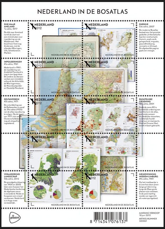 Netherlands 2012-06-18 On June 18, 2012, the Netherlands Post (PostNL) issued a fascinating sheet depicting the well known “Bosatlas” an educational atlas used by schools throughout the Netherlands. The sheet was issued to celebrate the latest edition of the DeGrote Bosatlas, the most popular atlas used in Dutch classrooms. “The Bosatlas, which forms the foundation of geography teaching in the Netherlands, has shaped how many generations of Dutch people view the world. The first Bosatlas was created in 1877 by Groningen teacher P.R. Bos and entitled Bos’ Schoolatlas der geheele aarde (Bos’s School Atlas of the Whole Earth). Many editions of the atlas have since been issued, with each new one summarising changes in the world, society and education.” The images of the Netherlands shown on the Bosatlas stamp sheet feature ten different stamps with the non-value indicator “1” and the designation “Nederland 2012.” The sheet depicts the inside pages of seven editions of the Bosatlas, the first one published in 1877, along with maps published in 1961, 1971, 1981, 2001 and 2007, and the very latest edition from 2012. The images on the sheets are arranged in the shape of the Netherlands. The sheet margins contain text explaining the contents of the pages shown. The font used is “Nobel,” a san serif typeface designed in the 1930s and used in all editions of the Bosatlas since 2004. In addition to the stamp sheet featuring ten different stamps, two stamp booklets, a prestige booklet and two first day covers will also be available. [Many thanks to Society Vice President Mark Honig who alerted us to this stamp prior to issue. There are a number of fascinating links about the backstory of the young designers who created this issue. If you have specific questions, please contact Mark. — web admin]
|
Welcome to the CartoPhilatelic Society Celebrating our 67th Year as a Society. Come and Join Us!
The CartoPhilatelic Society has entered our 68th year as a Society! In 1955 a group of philatelists with a keen interest in map stamps founded the CartoPhilatelic Society. Today we carry on their passion for map stamps in the collections we assemble and the research we conduct.
Come and join us as we look forward to the future!
Web Site Last Updated:
July 24, 2023
Our Visitors Map Updated 2015-09-21. Thanks to all 19941 unique visitors!

A one year term of membership for the CartoPhilatelic Society runs April 1 through
March 31. Unless you have pre-paid for multiple years, or renewed you dues, your membership has expired at the end of March 2023
If you have not yet paid, please continue to support the Society and renew your dues for the forth-coming term (April 2023 through March 2024) as soon as possible.

A big "Thank You!" to all those members who have recently renewed their membership! The CPS appreciates your continued support and donations.
Visit our Membership page for information.
|
|
 CPS Resource Centre