CPS Resource Centre
![]() More details of the 5th meeting of the CartoPhilatelic Society have been recently announced in the April 2012 issue of The New CartoPhilatelist journal (page 11). The meeting will take place in New York City during the week of the ASDA National Postage Stamp Show 2012 that runs from October 11-14, 2012. Our Society meeting will take place at The Collectors Club, 22 East 35th Street, New York, NY at 3:00 pm on Friday, October 12, 2012. More information about the ASDA National Postage Stamp Show is available on the ASDA web site. Members interested in joining our meeting should contact David Wolfersberger for more details.
More details of the 5th meeting of the CartoPhilatelic Society have been recently announced in the April 2012 issue of The New CartoPhilatelist journal (page 11). The meeting will take place in New York City during the week of the ASDA National Postage Stamp Show 2012 that runs from October 11-14, 2012. Our Society meeting will take place at The Collectors Club, 22 East 35th Street, New York, NY at 3:00 pm on Friday, October 12, 2012. More information about the ASDA National Postage Stamp Show is available on the ASDA web site. Members interested in joining our meeting should contact David Wolfersberger for more details.
|
|
||||
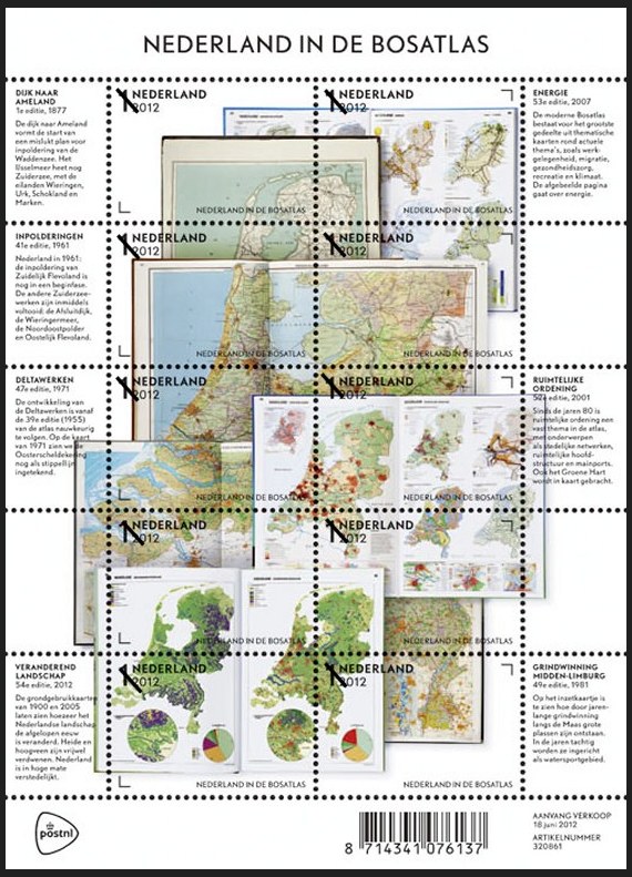 Netherlands 2012-06-18 On June 18, 2012, the Netherlands Post (PostNL) issued a fascinating sheet depicting the well known “Bosatlas” an educational atlas used by schools throughout the Netherlands. The sheet was issued to celebrate the latest edition of the DeGrote Bosatlas, the most popular atlas used in Dutch classrooms. “The Bosatlas, which forms the foundation of geography teaching in the Netherlands, has shaped how many generations of Dutch people view the world. The first Bosatlas was created in 1877 by Groningen teacher P.R. Bos and entitled Bos’ Schoolatlas der geheele aarde (Bos’s School Atlas of the Whole Earth). Many editions of the atlas have since been issued, with each new one summarising changes in the world, society and education.” The images of the Netherlands shown on the Bosatlas stamp sheet feature ten different stamps with the non-value indicator “1” and the designation “Nederland 2012.” The sheet depicts the inside pages of seven editions of the Bosatlas, the first one published in 1877, along with maps published in 1961, 1971, 1981, 2001 and 2007, and the very latest edition from 2012. The images on the sheets are arranged in the shape of the Netherlands. The sheet margins contain text explaining the contents of the pages shown. The font used is “Nobel,” a san serif typeface designed in the 1930s and used in all editions of the Bosatlas since 2004. In addition to the stamp sheet featuring ten different stamps, two stamp booklets, a prestige booklet and two first day covers will also be available. [Many thanks to Society Vice President Mark Honig who alerted us to this stamp prior to issue. There are a number of fascinating links about the backstory of the young designers who created this issue. If you have specific questions, please contact Mark. — web admin] The 37th issue of The New CartoPhilatelist shipped to members in early April, 2012. The spring issue is full of many exciting articles submitted by our members. A new multi-part article on Captain in Jame Cook and CartoPhilately by James Hamilton starts off this issue. The first article in the series provides an in-depth examination into Cook’s life, and his enduring legacy on exploration, richly illustrated through a number of classic Cook stamps. Future installments of the article will examine cartophilatelic images from Cook’s subsequent three voyages and will be illustrated using 68 cartophilatelic stamps featuring Captain Cook. Next up is a very interesting article on early French aviation history by Roger Kiby. France was in the forefront of aviation in the early 20th century and this article highlights those developments using a number of beautiful and well-known map stamps. Miklos Pinther provides another popular installment of “At the Auctions” giving details of an auction where the original map used as the model for the 1898 2 cent Canadian Christmas issue (Sc 85) was sold. Volker Woesner celebrates the 500th birthday of Geradus Mercator this year with a new and detailed article about stamps featuring images of the famous Mercator projection. In the next article, Tom Tarabicos share some personal experiences and unique history about the map stamps of the Cayman Islands. In Society News by President David Wolfersberger a number of important items are listed. Of primary importance is the planned meeting of the Society that will take place in New York City in October 2012. The issue is rounded off with updates to the checklist and a number of new issue images.
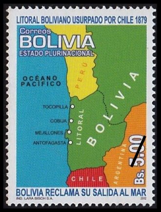 Bolivia 2012-03-12 Correos Bolivia has issued a new map stamp on March 12, 2012. The 5.00 Boliviano denominated stamp shows Bolivia’s borders, extending to the Pacific Ocean, as they were in1879 at the start of the “War of the Pacific” or “Saltpeter War.” When the war ended in 1884, Chile had taken control of the Litoral region and Bolivia became a land locked country. There are a few other Bolivian stamps depicting these border changes. [any additional information or an improved scan is welcomed –web admin] 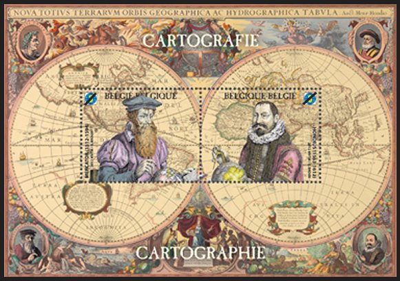 Belgium 2012-03-12 A new two stamp mini-sheet was issued by Belgium Post on March 12, 2012 to mark the 500th anniversary of the birth of Gerhard Mercator. The “Rate 3” denominated (€ 7.14) sheet features two stamps, the left one of Gerhard Mercator and the right of Jodocius Hondius. The background of the sheet appears to be an image of the “NOVA TOTIVS TERRARVM ORBIS GEOGRAPHICA AC HYDROGRAPHICA TABULA,” published in 1633 by [i believe] Hondius’ son Henricus. Hondius helped to re-establish the reputation of the work of Mercator, through the reissue and expansion of a series of previously published Mercator works. This is another fine looking cartophilatelic item for 2012. 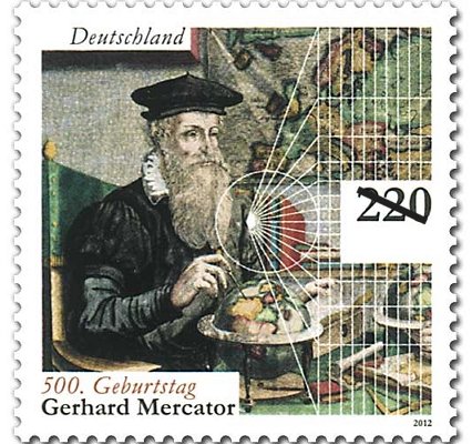 Germany 2012-03-01 The 500 year anniversary of the birth of Gerhard Mercator on March 5th was marked by German Post with a new high denomination stamp. The€2,20 square format issuefeatures an image of Mercator in the foreground holding what appears to be a pair of calipers placed on a small globe resting on a table. In the background, is a map of Europe and a series of white construction lines radiating from a single point forming what appears to be the graticule of the famous Mercator projection.“Mercator was born Gerard de gemor or de Cremer in the Flemish town of Rupelmonde, Mercator is the Latinized form of his name. It means merchant”. In 1554 he completed a large six panel map of Europe, with a second edition in 1572. Originally created by Erhard Etzlaub in 1511, Mercator refined the techniques and used the projection in a large world map, published in 1569. The projection had parallel lines of longitude to aid navigation by sea, and compass courses could be marked as straight lines. It was this projection that now bears Mercator’s name. Mercator was also thefirst person to use the term “atlas” for a collection of maps. Mercator started production of an atlas that was not fully published until after his death in 1594. [ in searching around on the internet, besides a number of articles celebrating Mercator’s birth, i found a very interesting item which indicates that there is an error in this stamp. if anyone has some additional information regarding this, please contact the web admin.] |
The CartoPhilatelic Society is proudly affiliated with the American Philatelic Society and the American Topical Association. Visit there web sites and learn about their activities.
|
|||
|
Copyright © 2026 The CartoPhilatelic Society - All Rights Reserved
About this web site: If you have any questions, comments or suggestions about this site, please contact the web site administrator. Unless otherwise stated, all content, images, text, separate files, on this web site are the Copyright of The CartoPhilatelic Society, and may not be used without written consent of the President, CartoPhilatelic Society. Powered by WordPress & Atahualpa |
||||