 The CarotPhilatelic Society held its 3rd meeting on February 2nd, 2008 at the Sarasota National Stamp Exhibition in Sarasota Florida. There were six members from the Society present at the meeting. The CarotPhilatelic Society held its 3rd meeting on February 2nd, 2008 at the Sarasota National Stamp Exhibition in Sarasota Florida. There were six members from the Society present at the meeting.
The first order of business was the Secretary/Treasurer Report. This report is detailed in the New CartoPhilatelist Journal, #21, April 2008
During the meeting Miklos raised the subject of a second volume in the Society’s Occasional Publication series and presented a copy of “Old European Road Maps” from the Postal History Journal (1980), which perhaps could be used as the basis for the second volume.
Another idea was to follow up on a reported sixth volume that Walter Klinefelter had in preparation at the time of his death. Al met his daughter recently and will contact her to see if there is anything there that perhaps we could take on and complete.
These discussions will move to the new Society member’s forum where they can be further discussed.
Martin Oakes was introduced as the new editor of the New CartoPhilatelist.
David reported that Revision 4 of the Maps on Stamps checklist is ready to go with only minor corrections being made. An announcement will be in the next issue of the TNCP. Several issues were raised about the Checklist:
David reported that were a couple of members interested in putting the Checklist into some type of database system, however there will be some tradeoffs in doing this. This discussion also, has started on the new Society member’s forum.
David also delivered a presentation sent from Reese concerning the Society’s web site. The report gave details into the differences between the two sites which the Society has and provides an overview of some new revisions and enhancements to the sites.
The next topic for discussion was Exhibiting, lead by Miklos. He presented a paper with a lot of information on exhibiting, including rules on exhibiting from the FIP and APS. Miklos mentioned several reasons for exhibiting and suggested that both individual and a Society exhibits might be in order.
Mark made a very interesting presentation on Maps on Gutters. Numerous examples from many countries were presented. David then concluded the formal meeting with a short presentation on map stamps of the Military Order of Malta.
A very nice sales/trading session followed with many of us adding to our collections.
Friday evening the Society group met at the Boathouse Restaurant at the Hyatt for a very nice dinner. The Saturday evening dinner was at Mariana Jack, an interesting place not far from the Hyatt. A wonderful time was had by everyone with plenty of talk and discussion.
All present agreed that meeting every two years would be appropriate. Two suggestions were made: One of the ASDA Mega-Shows in New York City, or the London 2010 Festival of Stamps (May 8-15, 2010, Islington). There seemed to be more favor for NYC since that would hopefully allow for more attendees.
We look forward to meeting more of our Society members at a future meeting.
  
  
Article Number 9: A Small Map Find, Jersey sc183
New Submission February 2008, Research, text and scans by David Wolfersberger
Our ninth Marginalia article was originally submitted in Feb. 2008 by then Society President David Wolfersberger is in regards to an interesting map discovery on Jersey sc183. –web admin
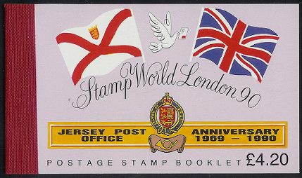
While looking through my small collection of golf related stamps, I came across a £4.20 booklet issued by Jersey in 1989. The booklet contains 12 each 18p (Scott 491), 14p (487) and 4p (480) stamps. This booklet commemorates several things: Stamp World London 1990, the 21st anniversary of the Jersey Post Office (1969-90), and the fourth set featuring “Scenes of Jersey”. The 18p shows the sunset over Corbiere Lighthouse; 14p has St. Ouens Bay; and the 4p shows golfers on a green at the Royal Jersey Golf Club.
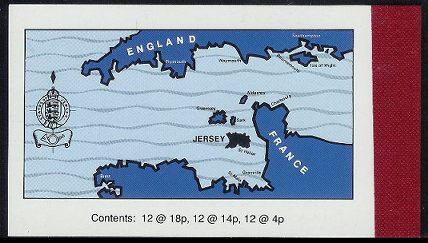
The cartophilatelic connection is a nice map on the back cover of the booklet showing the English Channel and the locations and names of all of the Channel Islands. A few locations in England and France are also noted.
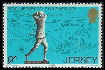
What is interesting is that this is not the first time this map has been used. In 1978 Jersey issued a set of 4 stamps marking the 100th anniversary of the Royal Jersey Golf Club. This set of 4 was issued in a small folder and on the back cover of this folder is the same map as on the 1989 booklet. One of the stamps, Scott 183, shown below, has a nice map of the golf course.
The Royal Jersey Golf Club is located on the east coast of Jersey on the Royal Bay of Grouville. google maps link
 Picture of Harry Vardon from US LOC circa 1910 Harry Vardon, one of the best and most famous golfers in the history of the game was born near the Royal Jersey Golf Club, a fact that is commemorated at the course by a small stone monument and a statue of Vardon.
The 1978 set shows the statue as well as other items relating to Vardon.
While not a stamp, maps such as the one on the back of this booklet cover are a nice addition to a maps on stamps collection.


Here is an interesting souvenir sheet, shown below, issued by Belarus on December 16, 2007. The single stamp souvenir sheet commemorates the Struve Geodetic Arc, a project lasting from 1816-1855 by German-born Russian scientist Friedrich Georg Wilhelm von Struve to determine the exact size and shape of the Earth. The original arc consisted of 258 triangulations with 265 station points. The arc passed through 10 countries and extended over 2800km, stretching from Norway to the Black Sea. Today, 34 of the original station points have been designated as a World Heritage Site. In 1964 Russia issued a stamp, shown on the right, marking the centenary of Struve’s death in 1894. [ while researching this sheet, a lot of interesting history and web sites are available. one such site is dedicated to World Cultural Heritage as shown on stamps. ]
Article Number 8: Color Omission Error on Portugal sc#1115
New Submission December 2007, Research, text and scans by Mark Honig
Our eighth Marginalia is in regards to a fascinating new color error that our member Mark Honig from The Netherlands has recently found.
Wanting to buy a mint copy of Portugal 1114 (4.50e Meteorological map) I saw a complete set being offered on eBay last year. I was the only bidder and I acquired the set for a few dollars.
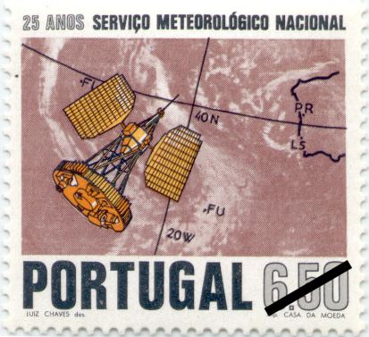 Portugal, 1971, 25 Years Meteorological Service
sc1115, mi1148, sg1434 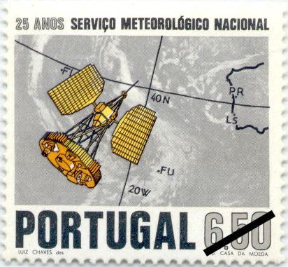 Color Variation
Portugal, 1971, 25 Years Meteorological Service
sc1115, mi1148, sg1434 When I added both map stamps from that set to my collection I discovered that I already had the other map stamp (sc1115), but in a different color. I already had a red colored 6.00e stamp, but on this newly acquired stamp the main background color is grey.
After checking various stamp catalogues at my disposal, it became clear that the stamp should have a red color. A grey variety is not mentioned in any of the catalogues, not even in the Portuguese Afinsa catalogue.
I also sent email messages to some Portuguese dealers however these messages remained unanswered.
In November 2005 I continued my research about this color variation and contacted the president of the International Society for Portuguese Philately (ISPP) in the US, Mr. Roy Texeira. Judging the stamp from only a scan, Roy feels the stamp has probably been bleached by sunlight or chemicals.
Personally however, I think that this specific stamp is a genuine color variety based on the following reasons:
- The set was offered as a normal set, not as a set with a variety.
- The seller has sold many items to me, with great satisfaction.
- The stamp is in perfect condition with a shiny surface like the red stamp.
- The gum looks normal
- The yellow and orange parts look the same as on the red stamp. When bleached these colors would probably have disappeared too.
The president of the Netherlands Society of Collectors of Spanish and Portuguese stamps “Iberia” also thinks the stamp is bleached, but he has offered to perform a test on the stamp, as he is an official expert with the Netherlands Museum for Communication (Prev. Netherlands Post Museum). The results of this test will be forthcoming.
One other item about this set…
During my continued research on this stamp, it became clear that there is also a cartographic design error on the 6.50e stamp. On the satellite image the coastline of Spain and Portugal has been overlaid, however during the design process the coastline of northwest Africa has been omitted. The 4.50e stamp does show coastlines for both the Iberian peninsula and northwest Africa.
Additional Notes:
If anyone knows more information about this fascinating color variation that Mark has found, please let us know. Regarding the missing coastline issue, I have made two checks to determine the map projection of this stamp and to also understand approximately how much of the African shoreline should be shown. One projection I checked was a Lambert Conformal Conic, the other was an Orthographic. I feel there is a significant amount of distortion with the map in question. We welcome any comments or suggestions. –web admin
 Spain 2006-07-13 On July 13th, 2006, Spain’s Postal Service, Correos, issued two stamps which appear to be the start of a series dealing with Earth and space sciences. A very representative cartophilatelic issue showing a detailed 1:200,000 scale topographic of Toledo and the surrounding region is shown along with a magnifying glass. You can read more about this new Spanish series on the Correos web site.
The Society held a meeting during the World Philatelic Exhibition in Washington DC. The full event ran from May 27, through June 3rd, 2006.

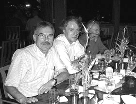
Here are some pictures of your fellow Society members who attended the meeting. We look forward to meeting more of our members at our next meeting.
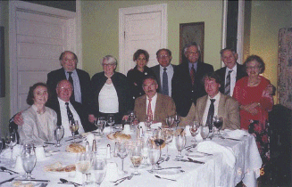 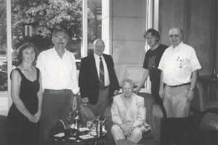
As this event has already finished, please check the website World Philatelic Exhibition for more details on the Washington 2006 World Philatelic Exhibition.
Tuesday May 30, 2006 (PM): Informal “get together” meeting at the Butlers Martini Bar in the Grand Hyatt, 1000 H Street NW, at 6:00 pm. For those who have not met any other members yet, David will be holding a beach ball in the form of a globe to help you easily spot our group. This is a strictly voluntary meeting and is just a way to meet informally prior to our planned Society activities the following 2 days.
Wednesday May 31, 2006 (AM): Tour of the Geography and Map Division of the Library of Congress. Meet at 9:45 am in front of the reading room LM-B01), by the large globe, in the basement of the Madison building of the Library of Congress. Check out the G&M web site at [http://www.loc.gov/rr/geogmap/ – it has a link to a map of the building and of the basement. Our host for the tour is Edward James Redmond of the staff of the LoC and of the Washington Map Society (WMS). Be sure to also check out the WMS at http://home.earthlink.net/~docktor/washmap.htm – we are institutional members.
Thursday June 1, 2006 (AM): CartoPhilatelic Society Annual Business meeting. This will be held in Room 149A of the Convention Center at 10:00 am.
Agenda items include:
Welcome and agenda review
Membership report
Financial report
Arrangements for trading and exchange of stamps
The New CartoPhilatelist – Recognition of new Editor, comments
“Scholarly” journal – any interest?
Checklist – comments?
A preview of a paper on map stamps due for fall publication in the Portolan, the journal of the Washington Map Society
I have downloaded the Level 1 Floor Plan and Marked Room 149A for your convenience here. [Web Admin]. More information about the Convention Center can be found at http://www.dcconvention.com/meeting/floorplans.asp.
Thursday June 1, 2006 (PM): Cartophilatelic Society Annual dinner and banquet: 6:30 pm at the Tabard Inn http://www.tabardinn.com/home.htm. Since we are less than 15 in number, it looks like, by the fine print, that we will be able to order at the time. We’ll double check this, and if not, get a menu distributed as soon as available. Remember, you will be billed for charges over the US$50 you have already paid (gratuity, alcohol/drinks, etc.).
We look forward to seeing you there!
David Wolfersberger
Alf Jordan
|
Welcome to the CartoPhilatelic Society Celebrating our 67th Year as a Society. Come and Join Us!
The CartoPhilatelic Society has entered our 68th year as a Society! In 1955 a group of philatelists with a keen interest in map stamps founded the CartoPhilatelic Society. Today we carry on their passion for map stamps in the collections we assemble and the research we conduct.
Come and join us as we look forward to the future!
Web Site Last Updated:
July 24, 2023
Our Visitors Map Updated 2015-09-21. Thanks to all 19941 unique visitors!

A one year term of membership for the CartoPhilatelic Society runs April 1 through
March 31. Unless you have pre-paid for multiple years, or renewed you dues, your membership has expired at the end of March 2023
If you have not yet paid, please continue to support the Society and renew your dues for the forth-coming term (April 2023 through March 2024) as soon as possible.

A big "Thank You!" to all those members who have recently renewed their membership! The CPS appreciates your continued support and donations.
Visit our Membership page for information.
|
|
 CPS Resource Centre